
Shallow Erosion Dynamics in mountain grasslands of South Tyrol: Monitoring, process analysis and mitigation measures
- Framework: Professional Internship
– Eurac Research, Center for Sensing Solutions, Institute for Earth Observation - Duration: 07.2019 – 01.2020
- Contributors: Levente Papp, Abraham Mejia-Aguilar, Ruth Sonnenschein (Eurac Research)
– Free University of Bolzano (Faculty of Science and Technology): Rita Tonin, Michael Loebmann
– University of Innsbruck (Department of Geography): Clemens Geitner, Martin Rutzinger, Andreas Mayr
– University of Salzburg (Z_GIS): Stefan Lang - More info: http://www.mountainresearch.at/erodyn/
- My role: Project Associate – as an Intern
- Contact person: Levente Papp – papplevente9610@gmail.com & Abraham Mejia-Aguilar – abraham.mejia@eurac.edu

Mountain environments are particularly vulnerable to ongoing climatic and environmental changes. Specifically, the valuable alpine grasslands are seriously threatened by shallow erosion which has been increasingly detected during the last decades on alpine meadows and pastures. It has been suggested that a high plant species diversity of alpine grassland communities may increase the erosion resistance of soils, mainly through positive effects on root length, number of root tips and foliage abundance. Moreover, high plant biodiversity has been shown to stabilize water channels by giving slope instability. Against this background, it is necessary to map the grassland areas on a large scale. In this project, we used Earth Observation to map grassland communities and to understand the link between species diversity and the presence of shallow erosion spots in an alpine region.
In this international project, our task was to classify the different grassland communities in high precision, using machine learning, in an area endangered by shallow erosion.
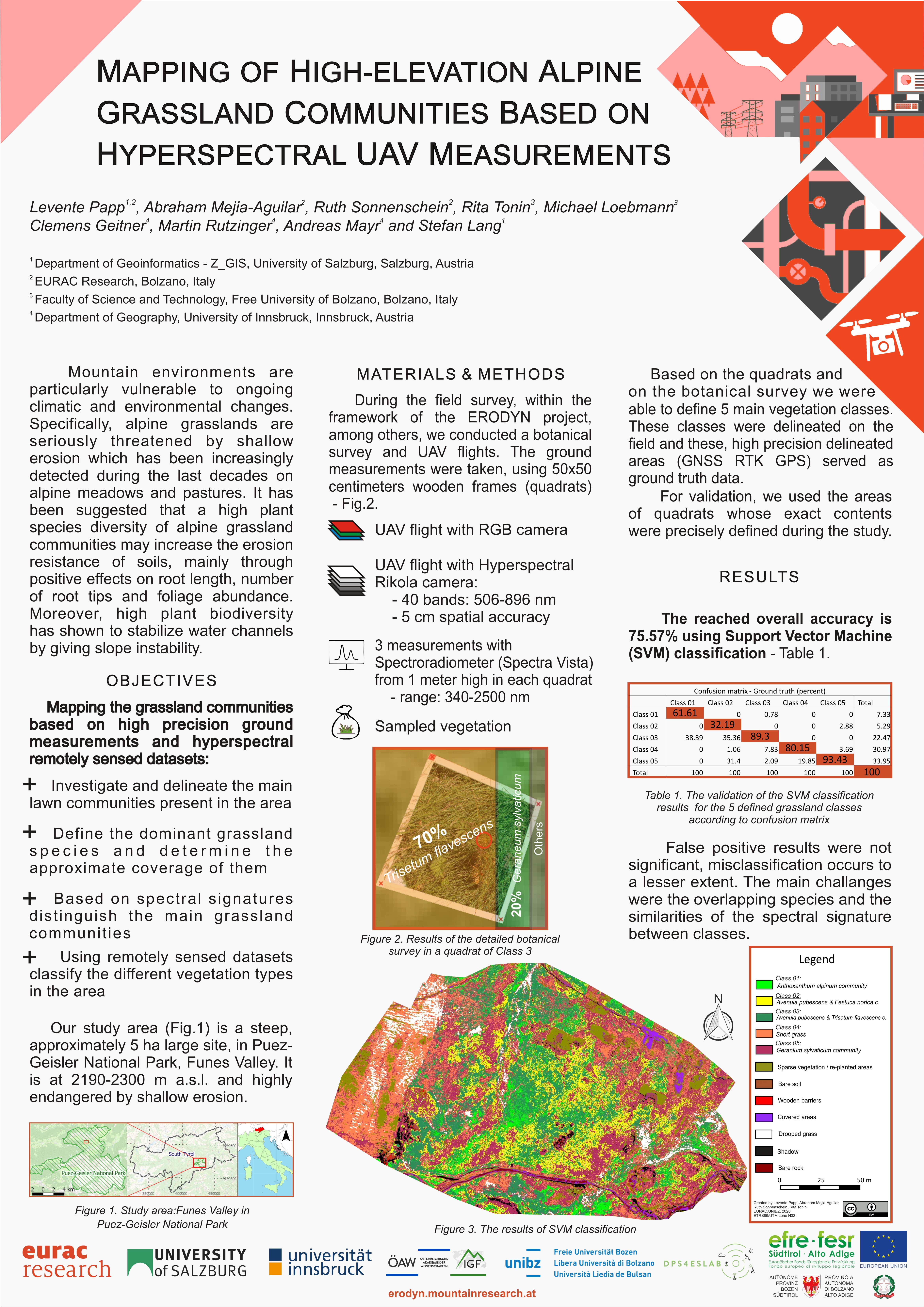
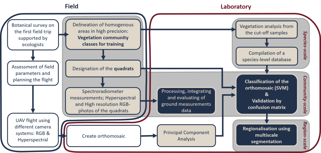
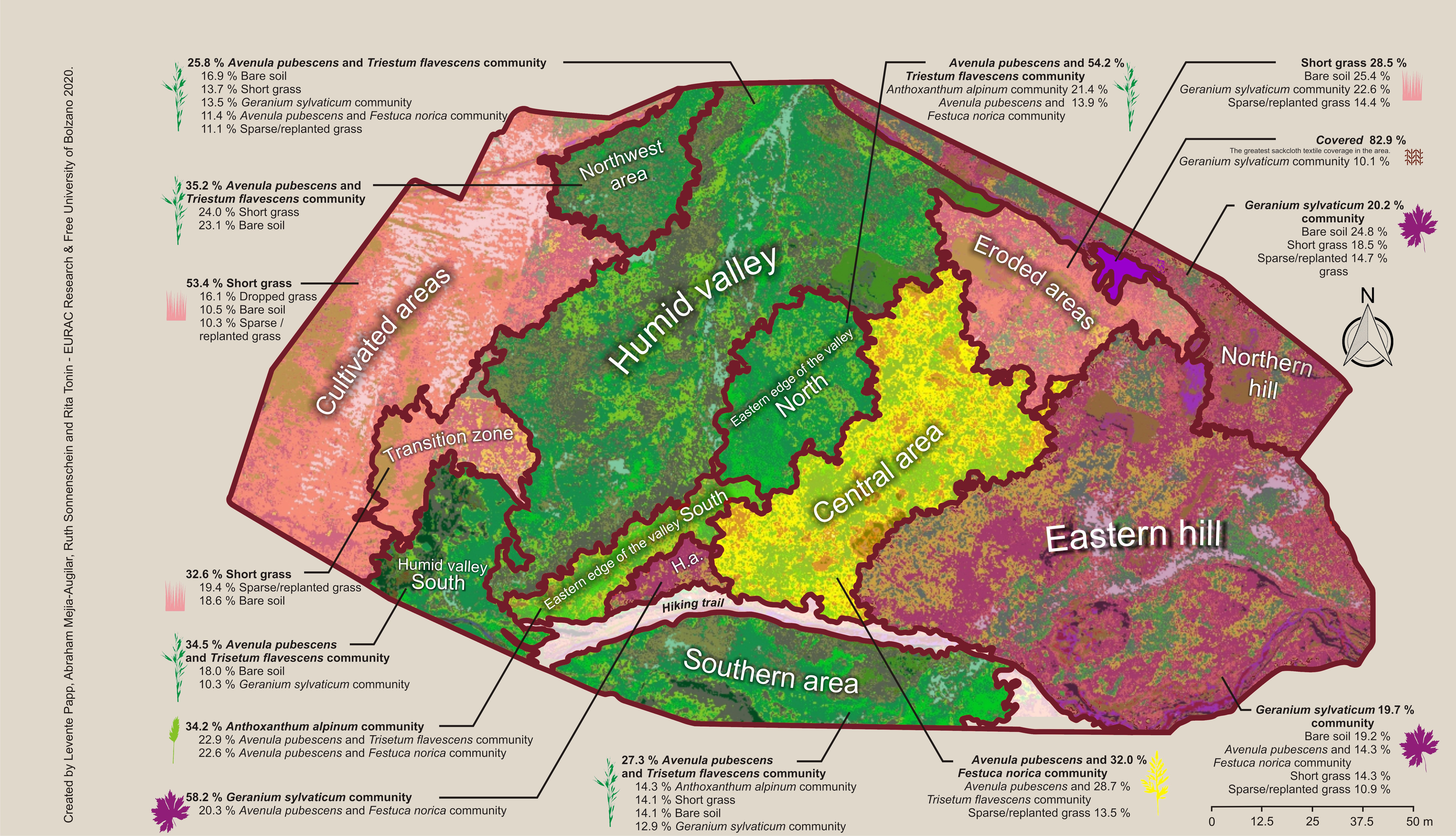
The study area is located in the Funes valley in South Tyrol, Italy, where shallow erosion plots have been increasing in recent years and decades. The study area lies at an altitude of more than 2300 m above sea level. Using different techniques, we mapped the grassland vegetation in this area at three different scales: species level, grassland community level and vegetation region level (local scale). The main source of data was a hyperspectral survey with a total of 28 spectral bands (506 nm to 896 nm), acquired with a spatial resolution of 5 cm, based on UAV. Our ground reference database consisted of detailed ground measurements within 50×50 cm quadrats. In total, we made field spectroradiometer measurements covering the spectral range from 339 nm to 2500 nm (1024 spectral bands), ground hyperspectral measurements, and sampled different grassland communities within the quadrats.

Funes valley study area RGB composite
Funes valley study area digital elevation model
Funes valley study area near-infrared composite (896 nm)
As a result of the data acquisition, the integration of ground and aerial data, the study was able to determine the vegetation cover of the area at the grassland community level. Furthermore, their content was quantified using a standardised sampling method – thus a detailed species list and database was built up. By surveying the grassland communities, a distribution map of the communities was produced using machine learning based pixel-based classification. Based on this, a small-scale vegetation region map (interpreted at local scale) was computed using an object-based image analysis (OBIA) approach (including multi-resolution segmentation) – Thus generalising and typifying the land cover of the area to support the further work to determine the most endangered regions.
Pixel-based image classification
Object-based image analysis approach
The overall accuracy achieved was 75.57% and the average user accuracy was 79.08% according to the confusion matrix validation. The false positive results were not significant, with a lower incidence of misclassification. The main challenge was the similarities in spectral signature between overlapping species and classes.
See Project Publications
|
|
|
|
|
|
The research leading to these results has received funding from the Province of Bolzano under the Research and Innovation action, within the interdisciplinary project, Shallow erosion dynamics in mountain grasslands of South Tyrol: Monitoring, process analysis and mitigation measures (ERODYN); http://www.mountainresearch.at/erodyn/, with grant B76J17000380003 and from the European Regional Development Fund, Operational Program Investment for growth and jobs ERDF 2014-2020 under Project number ERDF1094, Data Platform and Sensing Technology for Environmental Sensing LAB (DPS4ESLAB)LAB.